
You could hear the shrieks of women, the wailing of infants, and the shouting of men… People bewailed their own fate or that of their relatives, and there were some who prayed for death in their terror of dying. Many besought the aid of the gods, but still more imagined there were no gods left, and that the universe was plunged into eternal darkness for evermore.
Pliny the Younger on Pompeii, 79 AD
Shifting ground and Continental Drift
There are global forces outside of human control which also make and remake islands, and indeed continents. The Earth formed from a ‘primordial nebula’, which has developed a layered structure (i.e. core, mantle and crust). Each layer has a different physical and chemical composition, which changes it’s structure and power. The heat generated with each layer rises to the surface, alongside other material, before being lost to space. It is the movement of this internal heat that drives the forces that result in the formation and destruction of land and ocean mass, and moves the continents. The movement of the Earth’s mantle can cause new islands from fractures in the Earth’s surface, and also, reshape islands as a consequence of Tsunamis or other earthly shifts.
The Earths surface therefore is under constant rearrangement, and this has a profound effect upon the surface geology and other aspects, including the hydrosphere and atmosphere. As the Earth’s surface changes, as to does the size and shape and size of the oceans, the circulation, and the configuration of the Earth’s climate.
Proof of Continental Drift and Plate Tectonics
The continental drift and plate tectonic theory has developed over time. It is widely accepted that Wittgenstein Continental Drift Theory accounts for the creation and destruction of many of our islands and land masses today. The main proof of it’s existence is:
1) The jigsaw-like fit of the continents, namely the coastlines of western Africa and eastern South America. It is worth noting however the coastlines have been formed from sea level, and changed through weathering and erosion, therefore the boundary lines are the most important evidence. There are some overlaps if you review how the continents lock, but these features have been a result of formations since the continents split.
2) Geological, flora and fauna compositions and continuity between continents that were previously joined. This includes similar rock types, archaeological finds and even species and their successions. Namely there is similar rock strata between the Appalachian and Caledonian mountain belts of eastern USA and NW Europe respectively. There is also the existence of Precambrian rocks and geological structures between South America and Africa. To further this, there is evidence of differing climates and rock types, including ice sheets, in geological discoveries that suggest the continents have moved. For example, there are warm-climate deposits found in northern Europe, Canada and even Antarctica. Coal reserves, derived itself from hot, tropical swamps, can be found in numerous temperate climates in Europe and North America.
3) Sea floor spreading is further evidence of the continental drift theory. During the Second World War, technology relating to submarines and sonar improved, and allowed us to effectively map the ocean floor. Scientists could also tell the temperatures and compare the topographic contrast between the ridges and the oceanic abyssal plains – this showed the thermal contraction of the crust as it cooled and spread away from either side of the ridge axis, proving the sea floor was spreading apart.
4) Palaeomagnetic studies and ‘Apparent Polar Wander’ (APW) shows that the Earth’s magnetic polarity has reversed numerous times in the geological past. Volcanic rocks have shown magnetic reversals, where the positions of the north and south magnetic poles exchange places. Although ‘Polar Wander’ was somewhat debunked, it is especially useful in charting the rifting and suturing of continents.
At the time of Continental Drift Theory, there was little understanding of the internal mechanisms of the Earth. For this reason, it took sometime for the theory to be accepted widely. Now we understand how the Earths core and mantle works, we have a better understanding of tectonics.
Plate Tectonics
The Earth is made up of many ‘plates’ which are interconnected, pushing next to each other and submerging under each other, causing stresses and strains to build up and release through shifts. They move as a result of molten rock (magma) which wells up underneath the mantle, piercing through fractures and areas of vulnerability. As the magma cools, this causes new land and can cause plates to push apart, which again can cause earthquakes.
See below for a rough global distribution of plate margins.
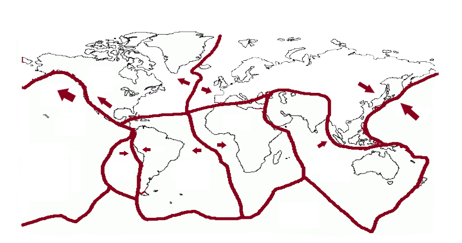
Where plates meet will often be a ridge of volcanoes, or historic volcanic mountain ranges and will suffer earthquakes and shifts. This is evident in the Ring of Fire in the Pacific Ocean where volcanoes line the fractures.
Have a look at places which suffer earthquakes and volcanic eruptions and align with the plate boundaries – they roughly line up. Can you find any incidences of earthquakes or volcanic eruptions NOT on a fault line?
Organic life can also build islands in more tropical regions, in that coral can latch onto newly formed ‘cones’ created by magma and build upon this. Coral can overtime build up, and alongside more tectonic activity, can reach surface level. Sediments and organisms can then inhabit this new land. Unlike the flows and continuous changes to global climate, which can be influenced by human activity, the tectonic processes are impervious to human intervention. Tectonics create, make and destroy islands. The volatility of the crust brings a new sense to the idea of territories, and the ability to create and destroy.
However, like magma can create life, it can also take it away. Volcanoes can emit ash and other toxic substances like sulphuric acid which can extinguish life by coating lands in lava and ash. of magma, similar to the movement of people, animals and water, can constitute as a flow. All these things are dynamic. The flow is gradual, but, can intensify and show itself as earthquakes and volcanoes.
Similar to Climate Change therefore, the flow of tectonics is a global process which affects us all, whether directly or indirectly. A volcano emission can prevent air travel, or destroy crops or destroy lass mass and civilisations, which affects everyone. The plates movements is a global affair and the crust works together.
Earthquakes
Earthquakes are the sudden violent shaking of the ground, which often occur due to plate movement where pressure builds and is released. Where the earthquake originates inside the Earth’s crust is known as the focus, and on the surface is referred to as the epicentre. The energy is released in seismic waves that move from the focus outwards, and are most powerful at the epicentre.
Earthquakes are measured using a machine called a seismometer which produces a seismograph. Earthquakes, until recently, have been measured on the Richter scale. The Richter scale measures the magnitude of an earthquake (how powerful it is) usually between 1 to 10. The Richter scale however is not very accurate in measuring larger earthquakes and today scientists use the Moment Magnitude Scale (MMS) (how much energy is released)
Volcanoes
A volcano is an opening or rupture in the Earth’s crust that allows hot lava, volcanic ash, and gases to escape from a magma chamber below the surface. They come in varying forms due to plate types and densities, as well is composition of lava and magma. The sea floor and some mountains were formed by volcanic eruptions, and the gas emitted formed the Earth’s atmosphere. There are more than 500 active volcanoes in the world, and more than half of these volcanoes are part of the “Ring of Fire,” a region that encircles the Pacific Ocean
Volcanoes can have a profound effect on the local environment, its shape and geology. Volcanoes produce ash, lava, volcanic bombs (large rocks ejected from volcanoes), pyroclastic flows (high speed current of hot gas and rock) and lahars (landslide of volcanic debris).
Positive Impacts
- Production of renewable, geothermal energy
- Ash is good fertiliser
- Tourist attraction which helps the local economy
Negative Impacts
- Can impact global climate – increase cooling
- Cause habitat and property damage
- They are dangerous and cause injury and death
- Can impact the economy as they cause society to re-build
Volcano Types
There are different types of volcano, which vary based on power and lava / magma type. There are two broad types of volcano, a stratovolcano and a shield volcano
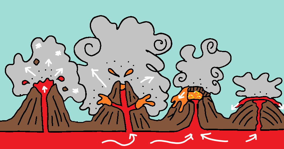
Cinder cones
These are the simplest type of volcano. They are built from particles of congealed lava ejected from a single vent. The lava can be viscous and slow to move, but forms a large cone.
Composite volcanoes
These comprise of some of the largest mountains. They are typically steep-sided and have multiple vents – allowing for alternating layers of lava flows, volcanic ash, cinders, blocks, and bombs.
Lava Domes
These are mounds formed by viscous lava flow that cannot travel much distance. It creates a mound in the crater and the dome grows from within, splitting at the sides
Shield volcanoes
These are built almost entirely of fluid lava flows, often made from basalt lava that is fast flowing and cools quickly. It creates gently sloping cones, spread over larger distances.
Have a look at different types of volcano and find an example for each one – what one is your favourite?
Types of Plate Margin
There are different types of plate margins, based on the type of physical processes that occur and lead to earthquakes and volcanic activity.
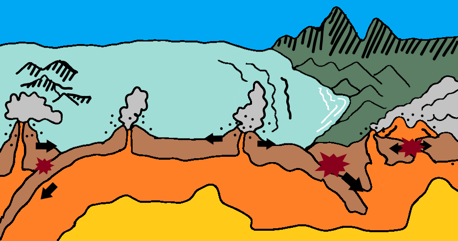
Conservative / Transform
A conservative plate boundary is one that rubs together, next to one another. This typically results in earthquakes more so than volcanoes. The movement can lead to topographical expression and fractures, such as at the Cocos-Nazca Ridge and the Pacific Ocean spreading ridge. There can be conservative plate boundaries at the edge of continental plates, namely the San Andreas Fault, which marks a segment of the boundary between the North American and Pacific Plates.
Example: North American Plate and the Pacific Plate
Constructive / Tensional / Divergent
A constructive plate boundary is one that splits together and builds new land from the lavaflow. It can form ridges, volcanic islands and some mountains. The process of fracturing, injection and eruption is repeated frequently, so that tensional stresses do not have time to accumulate significantly and, as a result, constructive plate boundaries are characterised by frequent, low-magnitude seismicity (typically less than magnitude 5), occurring at shallow crustal depths (<60 km) along the ocean ridge systems. Finally, it should be noted that constructive plate boundaries by definition cannot occur within continental lithosphere as they must be bounded by new oceanic lithosphere.
Example: The Mid-Atlantic Ridge
Destructive (subduction zones)
A destructive plate boundary is one that destroys land, as one plate goes under another. Typically an oceanic plate converges with a less dense plate, and the heavier plate dives sinks into the mantle. The downward-acting force is referred to as slab-pull force, and is related to the angle at which the plate descends. The force is greater for steeply dipping plates. However, the sinking slab encounters resistance as it descends, both from the frictional drag and from the viscosity of mantle material that is being displaced: this combined resistive force is termed slab resistance. The action of destructive boundaries creates fold mountains and trenches.
There are three possible types of destructive plate boundary: ocean plate v ocean plate, ocean plate v continental plate and continent plate v continent plate (See Collision)
The convergence of two oceanic plates sees the destruction of oceanic lithosphere, often resulting in island-arc volcanism and deeper earthquakes in excess of 600 km. While many ocean trenches are particularly deep, others are not. However, they are still characterised by a strongly negative free-air gravity anomaly, implying that they are filled with low-density material.
Example: Pacific Plate and the Eurasian Plate
When an oceanic plate converges with a continental plate, it is always the ocean plate that subducts beneath the continental plate. Continental lithosphere lies at a higher surface elevation than oceanic lithosphere because of its lower overall density. The Andes and the parallel ocean trench are one example of this and is marked by active volcanoes and an ocean trench causing earthquakes.
Example: Nazca Plate and South American Plate
Collision
A collision plate boundary typically occurs when two continental plates move towards each other. Due to density, one plate doesn’t easily submerge, and instead they collide. Such collisions result in intense deformation at the edges of the colliding plates, and those sea-floor sediments that were not subducted become folded and compressed into immense mountain chains or orogenic belts. Active mountain belts, such as the Alps and Himalayas in Eurasia, and the Rocky Mountains in the USA and Canada, are generally much wider than mountain belts. The mountains would eventually succumb to erosion over time, and their elevation can be decreased once tectonic activity ceases.
Example: Australian and the Eurasian Plate
Triple Junctions
There are some localities where three plates are in contact, and involves a ridge (R), ocean trench (T) or transform faults (F), which can be considered either stable or unstable.
An RRR junction are always stable, while a TTT junction is always unstable unless moving in the same direction.
Seven types of triple junction exist in the present plate tectonic configuration. These are:
- RRR (e.g. in the South Atlantic, the Indian Ocean and west of the Galapagos Islands in the Pacific)
- TTT (e.g. central Japan)
- TTF (e.g. off the coast of Chile)
- TTR (e.g. off Moresby Island, western North America)
- FFR, FFT (e.g. junction of the San Andreas Fault and the Mendocino Transform Fault off western USA)
- RTF (e.g. southern end of the Gulf of California).
Example: Australian and the Eurasian African, South American and Antarctic Plates (RRR)
Non-Plate Tectonic Activity
In the interior of some plates, there can be broad surface up-doming, which is often 1000 km across and hundreds of metres in elevation, presumably caused by an upwelling mantle known as mantle plume. Mantle plumes are an important feature of mantle convection, and produce surface volcanism that is not necessarily associated with plate boundaries. There are numerous plumes of different sizes recognised around the globe. Some are associated with chains of islands and seamounts, whereas others have produced long ridges in the ocean floor. A good example is the Ninetyeast Ridge in the Indian Ocean. They are referred to as aseismic ridges because of a lack of seismicity along their lengths, while these ridges have very different structures from the ocean ridges associated with constructive plate boundaries.
More recently, there have been reports of earthquakes caused by drilling and fracking, the action of sourcing natural gas from using high-pressure air and chemicals penetrating the Earth.
Climate Change and Tectonic Activity
Tectonic activity can have a profound impact on the climate. As the plates move, they directly impact the topography of land, it’s geology and atmosphere to name a few features. The increasing and decreasing oceans, coupled with land changes, can impact the climate and temperature. A short-term impact is volcanic material, such as ash, blocking solar radiation and causing global cooling. Given the clear link between ocean circulation and climate, plate tectonics is responsible for long-term changes in global climate.